Our knowledge on oceans in the world is extremely beneficial. For better life in future, we should manage marine resources wisely. All this time, human treat oceans badly and we does not carry out a sustainable development. We can see it in climate change, marine pollution, unsustainable extraction of marine resources. Moreover, the last worst thing, are physical alteration and destruction of marine as well as coastal habitats and landscapes. We can reduce the threats at least if we have better knowledge on oceans in the world.
There are five oceans in the world. Then, there are four name oceans having been already agreed in human history. These include Atlantic, Pacific, Indian, and Arctic Oceans. The fifth named ocean, i.e. the Southern Ocean or Antarctic Ocean remains debatable. The International Hydro graphic Organization has been proposed on the matter in the year 2000.
However, the international organization does not ratify the proposal until right now. There are some differences on the proposed boundary of the fifth ocean. Five oceans are our part of one blue planet. As our part of one blue planet, we should place it as the important subject in a sustainable development, particularly for us, Indonesian society who live in an archipelago country in the world.
Surface
These five oceans cover 71 percent of the world’s surface. Saline water in ocean holds 97 percent of the world’s water, and the remaining three percent is in a kind of freshwater. Saline water is also in seas of the world, such as Java Sea, South China Sea, Mediterranean Sea. People often say sea for ocean and on the contrary. We know better about sea because it is near land or partially enclosed by land and the margin of ocean. Therefore, sea meet land and ocean as well as it is smaller than ocean.
One thing we know at first when we go down to the beach for a swim is current. Ocean occurs particularly when ocean water moves in a continuous flow. Ocean current is divided into two types: surface current and deep water current. In surface current, surface circulation occurs.
Then, wind circulation in the earth’s atmosphere is factor of surface circulation. Other factors include rotation of the earth, differences in temperature, water salinity and coastal configuration. It occurs on 10 percent of all the water in ocean, particularly 400 meters of upper ocean water. Moreover, in deep water current, thermohaline current occurs. It involves 90 percent of all the water in ocean. It occurs along ocean basins for water density and gravity. As we have known that water density gets influence from salinity and temperature.
Surface current in the northern hemisphere has clockwise pattern and in the southern hemisphere it has counterclockwise and circular pattern. The pattern is relatively stable, and it is frequently called a nearly closed system known as gyre. In thermohaline current, water density differs from different regions. The denser saline water from the pole will sink in deeper ocean layers.
In addition, the combination of surface and deep water current transport warm water from equator toward the pole and cold water from the pole toward tropical region. The circulation makes heating distributed evenly throughout the earth’s parts. Therefore, ocean current has great contribution to climate change in the world.
Topography
As the study of numerous land-forms, topography of the ocean floor is the same as that of ground floor consisting of valley, mountain and plateau. There is an intermediary region between the ground and ocean called continental margin consisting of continental shelf and continental slope. In the foot of the slope, the stonework of continental crust changes to basaltic crust of ocean. There is deep valley in ocean, and it is a part of continental slope. The occurrence of the deep value is due to earthquake or ocean current.
On the other hand, the ocean floor topography also divides the ocean floor into several zones depending on the depth, namely Abyssopelagic Zone and Hadalpelagic Zone. Therefore, the different topography of ocean floor is due to the combination of volcanic, tectonic, deposition and erosion processes. Among the above factors, volcanic and tectonic are great factors to effect the establishment of the ocean floor.
Ocean itself has important position in human life. For three-quarter and 97 percent of the earth’s water, ocean has important position in earth’s life, such as the oxygen production and carbon absorption. It has important position in the world’s economy activities. Without ocean, the transportation of tremendous foods and goods will be difficult to deliver throughout the world.
From the short discussion on oceans in the world at above, we focus here on ocean currents and its effect to adjacent lands, topography each ocean throughout the world, and finally the importance of each ocean in world life including for humankind.
Pacific Ocean
Pacific Ocean has the width of more than 30 percent of the Earth’s surface and holds more than half of the Earth’s open water supply. It is the largest water mass on the planet. The width is more than landmass of all the continentence in the world if combined. Pacific Ocean is located between Asia and Australia in the west, Artic Ocean in the north, the Americas in the east and Southern Ocean in the south.
Despite bumpier and mountainous, average ocean depth is estimated around 12.080 feet or 3.682 meters. It was calculated by the satellite measurement in 2010. Marina Trench located at Challenge Deep is the deepest place in Pacific Ocean and all the oceans in the world.
The ocean has some unique. The ring of fire cause frequent earthquake and tsunami here. It has atoll, archipelagos including the biggest one located in Indonesia, most of islands in the world and the Great Barrier Reef in Australia.
[table]
[tr][td]Depth[/td] [td]12,060 ft (3,682 meters)[/td][/tr]
[tr][td]Temperature[/td] [td]10°C – 4°C[/td][/tr]
[tr][td]Topography[/td] [td]Flat[/td][/tr]
[tr][td]Width[/td] [td]30% of Earth’s Surface[/td][/tr]
[/table]
Currents
 There are some important currents in Pacific Ocean. These include North Equatorial Current, South Equatorial Current, Counter Equatorial Current, Kuroshio System, Oyashio Current, California Current, Peru Current, East Australia Current. These are surface currents moving warm and cold water in the ocean.
Some scientists divides these currents into South Pacific Gyre, North Pacific Gyre and Subpolar Gyre. The currents called gyre makes a closed system, South Pacific Gyre and North Pacific Gyre will not meet in equator. In equator there is Counter Equatorial Current.
The currents of Pacific Ocean have great influence to adjacent lands. In general, ocean currents greatly affect earth’s climate. Firstly, warm ocean currents increases temperature and lead rainfall condition in adjacent lands. It raises cloud cover, temperatures of winds and warm wind, high humidity due to the relatively high temperatures as well. Secondly, cold ocean currents lead to control temperature and these lead to arid conditions or form marine deserts. These also lead in low humidity for low evaporation rate, and these form cold offshore fog or misty condition for rapid radiation cooling.
Topography
The topography of Pacific Ocean is very flat. It also occurs in areas with seamounts or deep trenches. The flat feature indicates that the floor is the continental slopes and its abyssal plains is also flat. Its trenches at subduction zone has the depth of below 11,000 m. The feature of oceanic crust is mostly basalt and gabbro and it differs from the continental crust with the dominance of granitic and sedimentary rocks.
Temperature
The temperature in Pacific Ocean is between 10 degree Celsius at 1,000 meters in deep and 4 degree Celsius at 2,000 meters in deep to the bottom. However, it has at a freezing point in polar and 25 degree Celsius in tropical region. The denser water in polar will sink and takes oxygen to deep water through thermohaline currents.
Trenches
The deepest parts in Pacific Ocean are located in the subduction trenches. It includes Marianas Trench at 11.000 meters in deep. Other trenches are in the southwestern Pacific at 10,000 meters in deep, Japan Trench over 9,000 meters in deep, Puerto Rico and Chile-Peru Trenches over 8,000 meters in deep. However, sediments from Columbia Rivers has covered Juan de Fuca Plate.
Bordering Countries
The bordering countries to Pacific Ocean establish Pacific Rim. The list of bordering countries is among others the United States, Canada, Mexico, Colombia, Costa Rica, El Salvador, Guatemala, Honduras, Nicaragua, Panama. As well as Chile, Ecuador, Peru, New Zealand, Australia. Then, in Asia, there are Thailand, Taiwan, South Korea, Philippines, Malaysia, Japan, Cambodia, Brunei, China, Indonesia, North Korea, Papua New Guinea, Singapore and Vietnam.
Pacific Ocean has given a great contributor to global economy. The contributor includes sea transportation with low cost between East and West, fishing grounds, sand and gravel for the construction industry. The important thing, i.e. offshore oil and gas fields. Southern China Sea conflicts relates to potential oil and gas fields. For those who live in Pacific islands, moreover, Pacific Ocean has significant role for their economic activities. However, Pacific Ocean as an ecosystem is in a peril due to overfishing activities, habitat destruction, pollution, and the raising water level due to climate change.
Atlantic Ocean
Atlantic Ocean is the second largest ocean below Pacific Ocean. Total area reaches 106,460,000 square kilometers. The number covers 20 percents of the earth’s surface and its water surface at 29 percent. It is located between Africa, Europe, the Arctic Ocean, Americas and the Southern Ocean. As a large, S-shaped body of water, it extends from a northern latitude of about 60 degrees to a southern latitude of about 60 degrees. Then, the body shape makes scientists to divide Atlantic Ocean into North Atlantic Ocean and South Atlantic Ocean with a different circulation system.
[table]
[tr][td]Depth[/td] [td]10,955 ft (3,339 meters)[/td][/tr]
[tr][td]Temperature[/td] [td]-2°C – 30°C[/td][/tr]
[tr][td]Topography[/td] [td]Across the continental rise[/td][/tr]
[tr][td]Width[/td] [td]20% of Earth’s Surface[/td][/tr]
[/table]
Currents
 North Atlantic Ocean has the clockwise currents. Such as Antilles Current, Gulf Stream, North Equatorial Current, North Atlantic Drift and Canaries Current. Moreover, Brazil Current, South Equatorial Current, West Wind Drift and Benguela. Then, current occurs in South Atlantic Ocean with counterclockwise.
There are Equatorial Counter Current and Guinea Current as a link between the two systems with different directions. Due to Coriolis Effect, the ocean currents in Northern Hemisphere turn right and in Southern Hemisphere to the left.
Ocean currents gets influence from wind. Gulf stream with warm water from tropical Caribbean carries about 150 times more water than the Amazon River. The current flows toward Europe. Then, the warm water from Gulf stream keep Northern Europe warmer than others in north. In Thermohaline circulation in North Atlantic Ocean with cold and dense water, ocean water freezes and forms sea ice. When temperature drops, density is higher. The seawater becomes saltier and denser then it will sink. Global conveyor belt with the combination of surface current and deep water circulation occurs.
Climate also gets effect from ocean currents. For example, climate in Northwestern Europe, Northwestern Africa and fishing in the Grand banks region. Three of them get effect from Atlantic Ocean Currents. Meanwhile, equatorial Atlantic Ocean Currents raises ocean water particularly in Western Atlantic. Antilles current raises water in Mexican Gulf. Economy activities also get effects from the climate change.
Width
Atlantic Ocean has varying width and the largest occurs off northeast America and northwest Europa. Hudson Bay, Baltic Sea and North Sea are on continental shelf and these form marginal seas. Mid-Atlantic Ridge extends from north to sound and two deeper basins occurs on the either side of the ridge. In addition, the ridge length is along 14.000 kilometers and its height up to 4,000 meters. The ridge peak appears on ocean surface to form islands in mid-Atlantic, such as Pico Island of Azores, Cape Verde Island, Bermuda and Ascension, Tristan da Cunha, St Helena and Gough. Finally, Atlantic Ocean has some through and trenches. The through includes Cayman and Puerto Rico, while the trenches are Romanche and South Sandwich.
Concerning economic activities, Atlantic Ocean has a great contribution to 52 nations in Africa, North America and South America that have coastlines with the ocean. Firstly, it has natural resources from seals, whales and of course, fish as well as oil and gas fields. It has sand and gravel aggravates. It develops economic activities with the above natural resources. Secondly, it has connect East and West with sea routes.
Indian Ocean
Indian Ocean is the third largest ocean in the world below Pacific Ocean and Atlantic Ocean. It covers 20 percents of the earth’s surface. The location spans from southern coast of Asia and eastern cost of Africa. It spreads to western cost of Australia and down to the Southern Ocean. From eastern cost of Africa to western cost of Australia, its width reaches 1,000 kilometers. Average depth of Indian Ocean is about 3,890 meters and the lowest point is in Java Trench with the depth of 7,258 meters. In addition, average temperature in Indian Ocean reaches 22 degrees Celsius and it is higher to coastal regions near the equator with 28 degrees Celsius. To the Southern Ocean, its temperature drops below 40 degrees south latitude.
[table]
[tr][td]Depth[/td] [td]12,762 ft (3,890 meters)[/td][/tr]
[tr][td]Temperature[/td] [td]22°C – 28°C[/td][/tr]
[tr][td]Topography[/td] [td]Flat[/td][/tr]
[tr][td]Width[/td] [td]20% of Earth’s Surface[/td][/tr]
[/table]
Currents
 Ocean currents in Indian Ocean are divided into those in Northern and Southern Indian Ocean. Currents in Northern Indian Ocean include South-West Monsoon Drift, Somali Current, North-East Monsoon Drift and North Equatorial Current.
While, currents in Southern Indian Ocean comprise of South Equatorial Current, Mozambique Current, Madagascar Current and Aquilhas Current, West Australian Current, and Antarctic Circumpolar Drift with cool current.
On the other hand, Monsoon currents make heavy rainfall in coastal region in islands and Asian landmass.
Trenches
As half an ocean, Indian Ocean has one linear deep, namely Sunda Trench. It has several trenches, such asa Lakshadweep-Chagos , St. Paul, Socotra-Chagos , Seychelles, South Madagascar, Prince Edward Crozet, Andaman-Nicobar and Carlsberg Ridges. There are many basins and the above ridges divide each basin. The most known basins are Arabian Basin, Central Basin, Mascarene Basin, South Indian Basin, South Australian and West Australian Basin.
Islands
Indian Ocean has a variety of islands, and the most islands have the characteristics of continental islands. Andaman and Nicobar, Sri Lanka, Madagascar and Zanzibar are the continental islands. Coral islands include Lakshadweep and Maldives. On the other hand, the volcanic-made islands include Reunion Island and Mauritius. These are located in the north and west. There is no islands in the eastern side of Indian Ocean.
Indian Ocean has important position for sea transportation. Some important waterways include the Strait of Malacca and Suez Canal. Some important ports are among others Singapore, Mumbai and Chennai ports, Aden, Jakarta, Mombasa and Durban.Then, busy sea transportation causes the development of coastal cities along the Indian Ocean, Mumbai in India, Colombia in Sri Lanka, Singapore, Perth in Australia, Darus Salaam in Tanzania and Durban in South Africa.
Bordering Countries
The bordering countries to Indian Ocean are the countries of Africa and Middle East in west side from Madagascar in Africa to Iran in Middle East. Then, countries in Southern Asia of Indian Peninsula are among others India, Pakistan, Sri Lanka, Bangladesh in north side. Next, countries in Southeast Asia are from Indonesia, Singapore, Malaysia, Timor Leste, Thailand plus Australia are located in the east of Indian Ocean. Finally, south of Indian Ocean is Southern Ocean.
Arctic Ocean
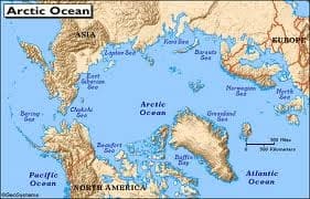 Arctic Ocean is the smallest five major oceans in the world. The location is entirely within Arctic Circle in Northern Hemisphere. Average depth in Arctic Ocean reaches 1,205 meters and the deepest is in Fram Basin about 4,665 meters. Then, Arctic Ocean has the boundary of Greenland, Baffin Island and other smaller northern islands.
In other words, the most water of Arctic Circle includes north of Arctic Circle. The other sides are the boundary of Europe, Asia and North America.
In North Polar, a drifting polar ice pack cover much of Arctic Ocean. It melts during summer months and for climate change the melting process occurs continuously. In general, thick ice covers Arctic Ocean along the year.
[table]
[tr][td]Depth[/td] [td]3,406 ft (1,205 meters)[/td][/tr]
[tr][td]Temperature[/td] [td]-1,8°C[/td][/tr]
[tr][td]Topography[/td] [td]Full of ridges[/td][/tr]
[tr][td]Width[/td] [td]20% of Earth’s Surface[/td][/tr]
[/table]
Topography
Concerning the topography of Arctic Ocean, there are some ridges,such as Nansen-Gakkel (Arctic Mid-Ocean Ridge), Arctic Ridge and Lomonosov Ridge and Arctic sub-basins Among these ridges there are some plains. Pole Abyssal Plain lies between Arctic Ridge and Lomonosov Ridge.In addition, Fletcher and Wrangel Abyssal Plain forms a basin between Lomonosov and Alpha Ridges. Canada Abyssal Plain is located between Canada and Alpha Ridge with a depth of 3,658 meters. Moreover, there is Arctic Ocean Basins as well. It has the depth of more than 4,000 meters in some areas.
Bordering Countries
There are eight countries with the border of Arctic Ocean. These include Russia, US, Greenland, Canada, Norway, Iceland, Sweden and Finland. However, other countries use Arctic Ocean including Japan. Melting ice and new developing industries threaten Arctic Ocean. In addition, melting ice will disturb thermohaline circulation in the region. The disturbance of thermohaline circulation will continue heating process in the earth. Moreover, new and developing industries will destroy natural environment.
Southern Ocean
 Southern Ocean is called Antarctic Ocean or South Polar Ocean. It also called as Austral Ocean or Great Southern Ocean. Antarctic ocean is the fourth largest ocean below Pacific Ocean, Atlantic Ocean, Indian Ocean. It is the newest named ocean, and the boundaries are not known yet. In fact, it surrounds Antarctic Pole and its considered to include South Pole. Some scientists consider that Southern Ocean as the extension of Indian, Pacific and Atlantic ocean. With the ocean area of 35 million square kilometers, it is larger than Arctic Circle. On the other hand, the bordering countries to Southern Ocean is Australia and New Zealand.
[table]
[tr][td]Depth[/td] [td]13,100 ft (4000 meters)[/td][/tr]
[tr][td]Temperature[/td] [td]-2°C -10°C[/td][/tr]
[tr][td]Topography[/td] [td]Farthest edges[/td][/tr]
[tr][td]Width[/td] [td]20% of Earth’s Surface[/td][/tr]
[/table]
Description
Iceberg and ice cover half of Southern ocean particularly in winter. For Antarctica is the windiest, driest and coldest continent in the world, Southern ocean is under the freezing point. Sea water under the surface of ice only reaches -2 degrees Celsius. That’s why, all activities here are in relation to scientific research. Average depth in Southern Ocean reaches 13,100 meters or 16,400 feet. The coldest temperature recorded on earth occurs in Antarctica. Concerning the topography of Southern Ocean, the scientists have developed its sea-flow with new map based on International Bathymetric Chart of the Southern Ocean program.
In conclusion, the discussion here focuses on some points. It finds interesting data on oceans in the world particularly human’s threat to ecosystem in the earth’s oceans, such as climate change, pollution, industrial activities and overexploitation to natural resources in these oceans. The destruction of Arctic Ocean will affect thermohaline circulation in the region. In long term, it will raise heating in the earth.